You Can’t Take The Sky From Me

First Warp

Open World? Try Open Universe

2016’s most anticipated (and harshest reacted to) game No Man’s Sky has been getting a lot of press. Some good, some bad. In my opinion, it’s making a lot of people think about what games are, could, and should be.

I was smitten when the original trailer for No Man’s Sky debuted at E3 2014.

It was a view at an optimistic space game. Not one focused on war or battle, but just exploration and the great unknown beyond. It almost echoes the mission of the Enterprise: “to explore strange new worlds, to seek out new life and new civilizations, to boldly go where no man has gone before.”

Pushing Boundaries But Not Enough

I’ve enjoyed my time in the Euclid Galaxy1 thus far. The game may be repetitive and have no real goals other than just looking around, but it’s the journey, not the destination, that’s important. The game is very reminiscent of early Minecraft, other than it lacks any building mechanic. No Man’s Sky encourages you to see what’s in the next star system. Maybe something great lies there or maybe it will be horrible. Maybe I’m reading too much into the game as an allegory for life.

In my opinion, it’s undetermined if the $60 is worth the price of admission. Once you’ve invested several hours in the game, the late game doesn’t change very much. The early game is spent trying to expand the amount of things you can carry, but unfortunately when your character is able to carry many things, there isn’t any amazing thing you can do. But I can see coming back to this game and universe often in future years for a few hours at a time.

This slideshow requires JavaScript.

No Man’s Sky was made by a ridiculously small team. Indie game development and game development in general is a rocky path to success. So I’m happy they’ve charged a full game price for the game. This is more sustainable for them to continue working on the game. I want to see more of what this game could be, so I am choosing to invest in it now. It may be a completely different experience in a few years, or it may not. The developers have been a bit dodgy with questions on what can happen when you come across another character in the game, and I believe Sony falsely marketed the game as an AAA release. But as a person who invested in Mighty No. 9 before that game even came out, I can tell you No Man’s Sky is much more enjoyable than that dumpster fire.

Imagine The Potential

When I travel to each new planet or star system, it makes me imagine a new open galaxy Metroid game starring Samus as she travels from star system to star system searching for answers about the Chozo2 while being hunted by the Space Pirates. The concept of No Man’s Sky will hopefully push the envelope of what is possible for the future.

No Man’s Sky is the closest thing out there that can simulate stepping into a world from science fiction where anything can happen. And you may be the only person ever to experience such worlds based on probability3. It has generated some feels for me unlike anything else and accomplished its goal of being able to step into a cover of a 70s sci-fi novel. Coupled with its amazing atmospheric soundtrack, it makes me feel alone in this vast universe4, and truly does capitalize on the the premise of to boldly go where no man has gone before.


  1. The games immense starting Galaxy. There’s more than one amazingly. 
  2. The now extinct race of people that raised Samus Aran after her parents where obliterated by Space Pirates. 
  3. The game features over 18 Quintillion planets. 
  4. Just like real life! 

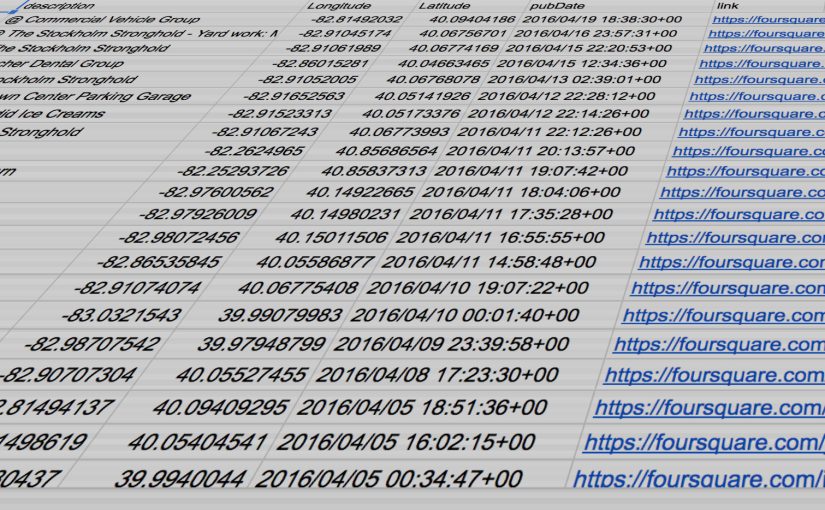
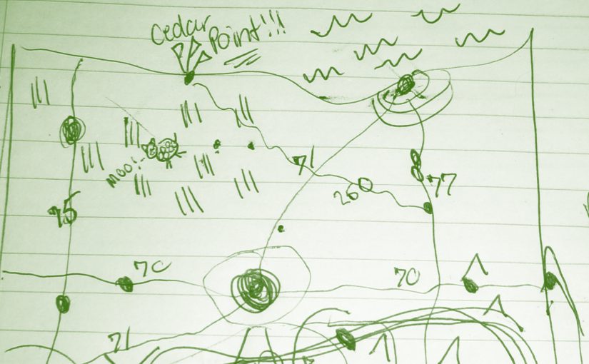
There’s A Map For That: Part Two

Can Foursquare/Swarm or other social media be viable in life logging and plotting on a map?

Overview

When Foursquare first appeared I was a very happy camper. The app allowed you to “check in” to locations and share with your friends where you were and where you’ve been. It was the perfect way to keep track of places in this digital landscape. Over time they added gamification features like points and badges based on where you’ve checked in. It encouraged a sense of adventure and discovery. For people who wanted to retain their privacy the app still allowed you to check in to locations to add to your digital map. For a time, they focused on features like seeing your history on a map and allowing you to export your checkins.

In 2014 Foursquare split the checkin functionality off to another app: Swarm. Foursquare was to focus on finding businesses, restaurants and providing reviews like Yelp.

Swarm since has consistently updated its app, but has focused on the game features rather than the digital life map. There are still ways to get your checkins out of Swarm to plot on a map, but they are a bit more complicated.
This post will outline the high level steps of what is needed to export and plot your data. It will assume the reader will have knowledge of CSV files, manipulating data within a spreadsheet, and access to Google Drive. 

Exporting Your Data From Foursquare/Swarm

Fortunately Foursquare still has a page to export your data, even though they’ve gone on record that they do not support this feature any longer.

By navigating here you can download a KML of your checkins, or a CSV. Each will allow you to plot on Google Maps, but what they do not retain is the latitude and longitude of the location, rather, they rely on geocoding1 to plot on a map. This is problematic as addresses can change. Additionally each of these export methods export every checkin which can get convoluted if you check in to locations multiple times. Checking in to the same location multiple times makes sense from a journalistic format, but if you want to plot places you’ve been to it can quickly over-clutter your map.

You’ll need to modify the URL of the export link in order to include all of your checkins. I suggest modifying it 9999. Example: https://feeds.foursquare.com/history/THISISANEXAMPLESOWHATCOMEATME.rss?count=9999

Optional parameters: You can specify a ‘?count=25’ to pull down a different number of checkins from your history. If you are requesting the ICS or Google Calendar formats your entire history is exported.

Foursquare Export Options

Cleaning Your Data From Foursquare

One other format that Foursquare allows you to export as is GeoRSS. GeoRSS is an older format2 but it does contain latitude and longitude information. If you export your data out of Foursquare this way, you can retain latitude and longitude, but you will still have all of your duplicate entries. From here you can go to this site and convert your GeoRSS format to a CSV file which will allow you to modify this data in your favorite spreadsheet application. (See example below)

Export Example. You may need to play with these settings a bit to ensure it exports the way you need it.

Within your favorite spreadsheet application (mine is Google Spreadsheets), you can remove duplicates based on a certain column. Now you should have a list of unique location checkins that you can export in CSV, or XLSX.

Plotting Your Data

Google has another application in it’s Google Drive suite called Google Fusion Tables. Fusion Tables allows you to import large data sets and display them in some sort of relevant fashion. Within Fusion Tables you can import your newly created Foursquare export data, and then plot it on a map within Fusion Tables. Once imported you can create a map view.

Google Fusion Table Map Plot

If you were to leave your duplicate entries intact you can display heat map data to show how often you are in certain areas. Additionally you could choose to filter this data based on your checkin dates, and more.

Once you make your fusion table downloadable you can then finally export your information as a KML file for plotting in Google Earth, Google Maps, or your personal backup.

Summary

So the answer to “Can Foursquare/Swarm or other social media be viable in life logging and plotting on a map?” is: Yes, but damn is it complicated for something that should be simple. I am surprised Swarm isn’t tapping into this a bit more in addition to the gamification options.

Hopefully you’ve found this informational3. Other social media sites that allow you to check in or store additional location data like Flickr4 are a bit harder to work with. Maybe someday I’ll find a way to show you how to work with those. At least while Foursquare allows you to export your data this is still a viable method. I hope other apps will allow you to do stuff with what is and should be your own data.

Next time, I’ll show you what you can do with an old handheld GPS unit.


  1. Geocoding is the process of reverse engineering an address to a physical location like latitude and longitude. Fortunately this is possible now but constantly needs to be updated with government information. 
  2. “but it checks out.” 
  3. If you are one of the tens of people looking for this. 
  4. Flickr used to be one of the innovators and advocates of geotagged information. They automatically geotagged photos from your EXIF metadata and plotted them on a map. Unfortunately you haven’t been able to see all of your photos on one map in a long time. But I hope one day this will be possible directly from Flickr. 

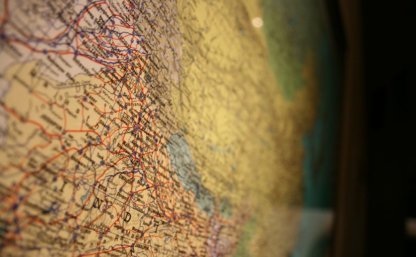
There’s A Map For That: Part One

How To Make Your Own Digital Map

Fortunately there are several free tools out today that allow you to store your own created maps. The best by a large margin is Google, who has put an amazing amount of effort into their mapping business since 2005. Anyone who recalls the Mapquest days can attest to this.

Google offers a feature called My Maps. My Maps allows you to easily create your own maps with pins, or routes, or even areas. You’ll need a Google Account in order to use this.

Google My Maps
Google My Maps

From there it is pretty simple. You can search for addresses or businesses or if you know the exact latitude and longitude, that’s available as well.

You can choose from different map views such as street view or aerial imagery. You can put your pins into different sets, add hyperlinks, or other information. You can even select different markers.

Google Maps Interface
My Maps Interface

Google allows you to share maps privately or publicly. If you share them publicly you can embed them on a website. Like so:

Once you’ve saved your map, it’s saved in THE CLOUD (Google Drive). But if you want to take things a bit further, there are more options. You can export your map, print it, or save it to a PDF.

How to export your data.
Export your data.

The export feature allows you to save your map in a KML format, which stands for Keyhole[1] Markup Language. KML is based on XML, and has become a standard for displaying location-based information on a map along with GPX (which we’ll get to in Part Three). As of right now, KML is a fairly reliable way of storing your location data to import into other programs, such as Google Earth, where you have more options to manipulate your data.

Unfortunately Google doesn’t currently allow you to edit My Maps on iOS, but they can be viewed in the Google Maps app on iOS. This is unfortunate as you’re most likely going to have your phone on you when you want to record your location. Android users are a little more fortunate. You can, however, send yourself a link of where you are, and add it once you get to a computer. Hopefully they fix this in the future.

My incomplete map of places Ive been
My incomplete map of places I’ve been


There are other ways of recording your locations on your phone without ever touching a computer. My suggestions for this are:
* Day One: A journaling app for iOS and Mac OS that allows you to record your location and more.
* Gaia GPS: A more advanced GPS app for your phone that allows you to store maps on your phone without a cellular signal, and record hikes or runs and export them a number of ways.

Now with this general information you can start building your own digital map. In Part Two, I’ll go over some social media apps like Foursquare/Swarm and Flickr, and show you how you can use them to add to your lifelong digital map, which will be a bit more advanced with xml data types. So if you want to go more in depth, stay tuned.


  1. Before Google Earth was Google Earth, it was Keyhole. Surprisingly the founder and CEO of Keyhole is the founder and CEO of Niantic, the creators of the new popular app Pokémon Go.  ↩

There’s a Map For That

Introduction

In 2016 we have more information available at our fingertips than ever before. Now we can navigate to many locations with relative ease compared to the old word-of-mouth directions and paper maps of yesteryear. GPS units used to be a luxury, but with the growing number of smartphones everyone has access to free up-to-date maps, whether it be Google, Apple, Waze, etc. In my opinion this is fantastic. We have a fairly accurate visualization of the world in the hands of billions.

Maps can relay information as well as stories. Location has always been important to me and deeply tied to my memory. For example, I was able to locate a motel my family stayed at when I was a youngin’ during a vacation to Kentucky with only a visual memory of the road and building layout. I was able to find it using satellite imagery on Google Maps. I haven’t been there in 20 years and didn’t remember any specifics, but I remembered the general area.

The past few years I’ve been trying to map places I’ve been to. Places that were memorable or interesting and might allow me to recall a story. And unlike pins on a map of United States on the wall, I’ve been doing it digitally with the latitude and longitude as precise as I can. The preciseness is important to me. Knowing I went a restaurant in a city is not enough detail. I prefer to know exactly where and when I was somewhere.

I may not be a globetrotter or adventurous as others out there, but I wanted to share some of the methods I’ve been using over the past years. While you could keep a journal and write everything down, there are a few ways to keep your lifelog organized digitally. These ways are not always intuitive but I hope they help you or give you ideas.

This isn’t meant for everyone. Some people like to keep their privacy, and not mark down on a map every place they’ve been. But if you like to keep track of things so that you may recall them in the future, I hope you’ll find the following useful. I am going to break this out to three different parts.

Stay tuned for each part soon.